

Located on the left bank of the Solu River, the barrage has 6 radial gate bays (7.5 m × 4.7 m each) with a crest elevation of 1760.0 masl.
The headworks comprises of gated barrage across Solu Khola, intake, feeder tunnels, underground desilting chambers, access tunnel, silt flushing tunnel. The size of barrage is 62.5m X 73m X 7.5m consisting of six radial gates. The designed flood discharge is 522 m3 /s (1 in 100 Years) and the designed discharge for the power generation is 20.42 m3 /s.
S.N | Description | Details |
Headworks Structure | ||
A | Type | Barrage |
b | Dimension | 62.5X73X7.5 |
c | Special feature | radial gated |
d | Gate Nos | 6 Nos |
e | Design flood discharge | 717m3/s |
f | Design discharge | 20.42 m3/s |
Underground Desilting Basin (Desander)
Situated on the left bank, designed to remove particles ≥0.25 mm with >90% trapping efficiency. It consists of 2 chambers (each 80 m long × 6.5 m wide) and a silt flushing tunnel (2.5 m × 2.5 m D-shaped, 238.6 m long).
From the desilting chamber, the water enters the 4,312.9-meter-long Head Race Tunnel (HRT). This D-shaped tunnel, with a finished diameter of 3.2 meters, acts as a low-pressure conduit, conveying water efficiently from the intake at Salme to the surge tank near Wassigaun. Its alignment has been carefully chosen to navigate the challenging Himalayan terrain, minimizing environmental impact and maintaining a steady hydraulic gradient.
S.N | Description | Details |
Headrace tunnel | ||
a | Length | 4312.9 m |
b | Shape | D-Shaped(excavated) and Horse shoe shape finished |
c | Size | 3.2m X3.2 m |
d | Lined/Unlined | Lined |
e | Percent of Lining | 100% |
f | Geological quality | Gneiss, Schist (most in weak geology) |
g | Total Length of water conveyance (intake, desilting, feeder, Hrt, pressure shaft, penstock, Tailrace) | 6894.5 |
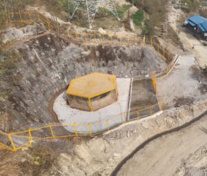
Located near Wassigaun, providing hydraulic protection for the headrace tunnel and penstock.
S.N | Description | Details |
Surge shaft | ||
a | Type | concrete lined vertical shaft |
b | Dimension | 72m *8m/6m dia |
The Underground valve house serves as the critical control node between the low-pressure conveyance system and the high-pressure penstock. It houses a spherical main inlet valve (1.2 m diameter) which acts as the primary isolation point for the turbine, allowing for safe maintenance and emergency shutdown.
Following the valve house, the 2,000-meter-long under ground pressure tunnel with steel lined penstock (2.8 m diameter) conveys water under high pressure to the turbine. This high-pressure pipeline harnesses the project’s substantial 491 m gross head, converting potential energy into the high-velocity jet that drives the turbines.
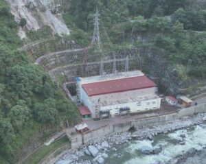
Located on the right bank of the Solu River at Bhadaure (elevation approx. 1266.5 masl). The powerhouse measures 65.725 m × 18 m × 30.5 m and houses 2 × 41 MW vertical-axis Pelton turbines.
S.N | Description | Details |
Powerhouse | ||
a | Type (surface/semisurface/underground) | Surface(pit Type) |
b | Dimension | 52.5mX36.2mX30.7m |
c | No of Units | 2 units of 41 MW each |
d | Switchyard position | Indoor 132KVA GIS |
e | Transformer type | Single phase |
f | Nos of transformer | 9 Nos (One Spare) |
g | Turbine type | Vertical Pelton |
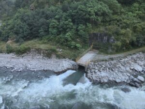
After the water has passed through the turbines, it flows into the tailrace, a short channel designed to safely discharge the water back into the Solu River. This discharge is carefully managed to prevent erosion and minimize any disruption to the river’s natural flow downstream of the project.
S.N | Description | Details |
Tailrace | ||
a | Type (surface/ underground) | Box Culvert and Tunnel combined |
b | Length | 230m |
c | Dimension | 4mX4m |
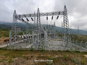
The final stage of energy delivery involves evacuating the power to the national grid. The project features a dedicated 132 kV double-circuit transmission line (4.2 km long), which carries the electricity from the powerhouse switchyard to the existing NEA Lamane Substation. This double-circuit design provides redundancy, ensuring a reliable power supply even if one circuit requires maintenance. Through the Solu Corridor, the power is then distributed across the nation, illuminating homes, fueling industries, and powering Nepal’s future.
S.N | Description | Details |
Transmission Line | ||
a | Voltage Type | 132KVA /double circuit |
b | Length | 4.12 KM |